Planner Emma Chow brought council’s attention to the section of Grafton Road where it takes a sharp turn at Charlie’s Lane. Pedestrians and cyclists navigating this turn, she said, tend to find themselves forced into the vehicle lane. Discussion on this corner and the need for more active transportation options on-island led to a decision to fund preliminary design work for a multi-use path on this stretch of roadway.
This decision essentially fast-tracks the implementation of the Integrated Transportation Master Plan’s (ITMP) vision for a multi-use path crossing the island.
“There’s a high latent demand for walking and cycling. This means a lot of people prefer to walk and cycle but don’t,” said Chow, referring to the information gathered through ITMP consultations. “Active transportation is important for public health and the environment, and right now, we have about 1km of sidewalks and zero kilometers of cycling infrastructure on the island.”
She added that islanders cited a multi-use path as their number one priority for local transportation.
The proposed route for such a path would connect Snug Cove with Tunstall Bay, travelling mostly along the westbound side of Bowen Island Trunk Road, Grafton Road and Adams Road. It would end at the corner of Adams and Bowen Bay.
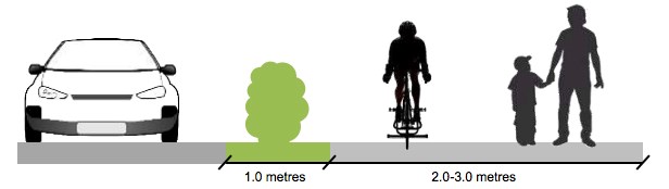
“All in all it would be about 6.5 kilometers long and ideally it would be paved and buffered, with enough width to accommodate both cyclists and pedestrians,” said Chow.
The corner of Grafton Road by Charlie’s Lane has been a longstanding barrier to the creation of such a path, and Chow told council that if a design for a path that deals with this corner can be put together within three weeks, the municipality could get 50% of the project’s cost covered by a $7.5 million TransLink fund for improvements in cycling infrastructure in Metro Vancouver.
Chow says the preliminary estimate of this project’s cost is between $250,000 and $300,000. This estimate covers the cost of survey, geotechnical and engineering work; blasting, bolting and meshing of the rock face; tree removal; road construction and line painting to cost between $250 and $300,000.
Councillor Gary Ander questioned moving forward on building a path along a roadway as opposed to one through the woods.
“This is a tremendous commitment, and it’s a quarter of a million dollars just to deal with 400 feet, do we really want to be beside the roadway? If that’s the decision that’s been made then I guess we’ll go ahead with it but I would prefer to not travel along a roadway,” said Ander.
He was reminded that building such a path through the forest would end up being much more expensive, and may not even be possible as the municipality does not own all of the land required to create a continuous path through the woods.
Councillor Sue Ellen Fast called the corner a longstanding issue, and recalled a video created by the Parks and Recreation Commission 20 years ago that demonstrated the precarious journeys of pedestrians navigating this turn.
Other councillors noted that other possible sources of funding for the path are available through various provincial and federal programs, as well as a potential contribution by the Grafton Lake Lands development.
Chow says that the Municipality may also receive funding from Metro Vancouver Parks and BC Hydro towards the path.
In the end, council unanimously agreed to put $5,000 in municipal funds towards the design of a multi-use path on the section of Grafton Road near Charlie’s Lane. Chow told council she had already contacted a number of design and engineering firms that were willing to take on the job right away. She says that this part of the project will be the most expensive part of creating a multi-use path.
“The cost accounts for why this has never been dealt with, and why it is important address it with the funding that is currently available,” says Chow. “Most sections of the path should be less than a third of the cost, on the per-metre basis.”
According to a report submitted to council this week by Municipal Manager of Finance Kristen Watson, BC Assessment reports an average increase of 20-25% for most properties on Bowen Island this year. There are 1,740 single family dwellings on Bowen, each with an average value of $960,000. In some cases, homeowners have seen their property values increase more than 60%. Local realtors say they are fielding calls from people questioning the assessment and looking for information about how to contest their assessments.


