After a year-long drought, the effects are obvious to anyone who ventures close to the two rivers that meander through Prince George.
Low flows have dropped the banks of the Fraser and Nechako several metres, leaving exposed areas of dirt and debris not seen in recent years and numerous gravel islands that are usually under water.
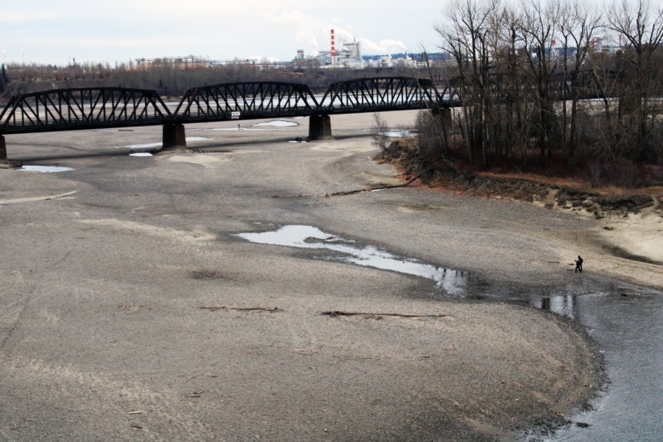
The confluence of the two rivers near downtown at Cottonwood Island is now a wide dry basin that draws curious walkers wanting to explore areas that might have required scuba gear had this been a typical year.
Early and rapid melting of the snowpack in the mountains last spring was a major contributor to the dry conditions and the lack of rain has worsened the drought.
Vanderhoof has had just 211 millimetres of moisture in the past 365 days - the driest year-long period ever recorded. Typically the city gets 465 mm of annual precipitation.
For perspective, any area on earth that typically gets 250 mm or less of moisture is considered a desert.
In Prince George, the city has had just 350 mm fall over the past 365 days. The average is 580 mm and 2023 is tracking as the second-driest year on record.
McBride, which typically gets more than 600 mm, has had 395 mm in the last 365 days.
Dave Campbell, head of the BC Rivers Forecast Centre, has been monitoring river levels and stream flow volumes from his office In Victoria and he’s seen some stations approaching record lows.
“We were experiencing a lot of record-breaking rapid melt this year,” said Campbell. “The dry side of things has been unprecedented and that’s leading to unprecedented stream flows in many areas and it’s certainly concerning to see.
“I’ve seen that in a number of spots, particularly on the Nechako side at the Isle Pierre gauge, that’s been tracking at historic low since September,” said Campbell. “That flow coming from the major tributaries of the Stuart River (which joins the Nechako River 45 kilometres east of Prince George) that’s also been tracking probably since August at its historic minimum.”
Water levels have been less than 10 per cent of normal on the Nechako at Vanderhoof. The Nov. 23 measurement of 1.59 metres was within a centimetre of the historic low of 1.58 m, which dates back to when readings were first recorded in 1950.
Closer to Prince George, water flows at the Isle Pierre station on the Nechako, downstream from the Kenny Dam, tend to fluctuate more because the release of water from the reservoir is controlled.
On the Salmon River north of Prince George, the Nov. 23 level was 1.01 m, not far off the record minimum of 0.82 m.
East of Prince George, the Dore River at McBride was down to 0.81 m, close to the record low of 0.74 m, while the Fraser River at McBride was at 3.06 m, approaching the 3.00 m record.
“The Fraser side hasn’t been quite as low but there have been periods where it’s been dipping down and it’s certainly low but not in historic territory,” said Campbell.
The Level 4 drought area includes the Upper Fraser East and West Basin areas as well as the Regional District of Fraser-Fort George. Level 4 drought means an adverse effect on socio-economic and ecosystem values is likely.
The Peace and Fort Nelson areas are in northeastern B.C. are experiencing Level 5 drought (the most severe) and adverse effects are almost certain.
On Monday, the village of McBride extended its state of emergency to Dec. 4 due to severe drought. The community of 600 people draws its water supply from Dominion Creek and water restrictions have remained in place since Sept. 19.


