This article was first published in the Undercurrent on December 18, 1992.
In 1983, Roy Bolton was having a shallow well dug on his land up the hill from Killarney Lake when his son Bob came across a large bone embedded in a blue clay layer about a metre below the surface.
Roy had the bone sent to Bill Matthews, a geology professor at UBC who had it identified as the femur of a sea lion. The bone and marine shells that occur with the bone, were dated by radiocarbon method at the Geological Survey of Canada at 12,500 years old. Roy Bolton’s land is over a kilometre from the closest shoreline and 85 metres above present sea level.
As sea lions never come farther on land than shoreline rocks, two possibilities exist. One is that part of a dead sea lion carcass was carried inland, possibly by a bear or early Native peoples. However, that explanation doesn’t account for the abundance of marine shells in the clay.
Instead, it is more likely that the position of the shoreline on Bowen Island has fallen hundreds of feet in the past 12,500 years (i.e. Roy Bolton’s land was once waterfront property).
There is other evidence that suggests an elevated sea level in the past. Compact bluish-grey sandy to pebbly clays that contain scattered marine fossils such as clams, barnacles and mussels are wide-spread below the soil layer in many low lying parts of the island (less than 100-150 metre elevation.)
Just north of Lions Bay, a thick gravel delta deposit is found at 150 metre elevation (visible just above Highway 99). This indicates that a stream entered the ocean at that elevation sometime in the past.
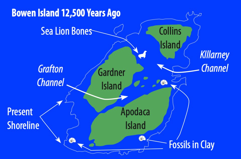
The evidence suggests that in the past, probably about 12,000 years ago, the parts of present Bowen Island less than 150 metres above present sea level has fallen dramatically. By outlining the 150 metre contour on a topographic map of Bowen Island, we can get a feeling for where the old shoreline was (see figure).
Instead of a single Bowen Island, there were the Bowen Islands, a cluster of three islands and several islets. The present three peaks of Bowen Island would have been each an island (Gardner, Apodaca and Collins Islands ?) separated by narrow straits of water that flooded the valleys of Killarney and Grafton lakes. These valley areas were a sea bottom on which clays, silts and scattered marine shells accumulated.
Today, these sediments commonly occur below the soil layer. Where very clay-rich, they are impermeable and thus poor for septic fields. The septic effluent instead of seeping into the ground flows along the top of the clays. A clay layer is well developed in the Deep Bay area and a factory that excavated clay for brick making operated along the shores of the present day lagoon in the 1890s. Many old brick buildings in Vancouver are built from Bowen Island clay.


